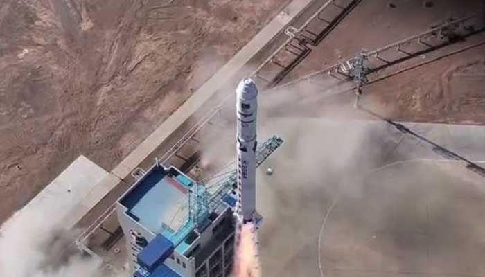
Pakistan on Sunday launched its first Hyperspectral Satellite HS-1 from China’s Jiuquan Satellite Launch Centre (JSLC), which will help forecast floods, landslides and other natural disasters.
Space and Upper Atmosphere Research Commission (Suparco) has broadcast the live scenes of HS-1 from Karachi Nuclear Power Complex. Addressing the event, a Suparco spokesperson said: "HS-1 satellite will help forecast floods, landslides and other natural disasters, support timely monitoring of environmental changes and geological hazards, and open new avenues for infrastructure mapping and urban planning."
The launch of Hyperspectral Satellite HS-1 marked a major success in Pakistan’s National Space Policy and Vision 2047. "Pakistan will be able to view every inch of the Earth with hyperspectral precision," the spokesperson added.
In a press release, Ministry of Foreign Affairs said: "The HS-1 satellite will contribute to development initiatives, including the China–Pakistan Economic Corridor (CPEC) by identifying geo-hazard risks and promoting sustainable infrastructure development.
Taking to X (formerly Twitter), @ForeignOfficePk shared: "This achievement also highlights the long-standing collaboration between Pakistan and China in the peaceful exploration of space and its application for socioeconomic progress."
Hyperspectral Satellite HS-1 benefits
With its advanced capabilities, the HS-1 satellite is entering a new era of modern technology and applications. Here are all the benefits of the HS-1 satellite mentioned:
In agriculture, the HS-1 satellite aims to provide high-resolution data to support correct farming. By giving insights into crop health, soil moisture and irrigation patterns, HS-1 will improve yield estimation by 15-20% sustaining food security.
For the development of urban areas, HS-1's sensor will help monitor environmental changes, map infrastructure and analyse urban growth trends.
With the data, Suparco can improve post-disaster evaluations, transportation network analysis, and water-resource modelling, giving timely insights into floods, earthquakes, deforestation and land degradation.
Earlier this year, Suparco launched E0-1 and KS-1 satellites into space, which are fully operational in orbit.


